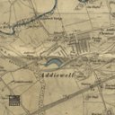
Ordnance Survey map showing Westwood and Easter Breich Estates. Oakbank Oil Company. Dated 1898.
code: 183324
Description
Envelope containing an 1895 (Second Edition 1898) Ordnance Survey map (2 parts) showing the area outlined in Red. It also shows in red ink the position of 3 bores to Broxburn and Dunnet shale seams. The Scale is shown as six inches to one statute mile or 880 feet to one inch 1/10560. There is also a plan undated reference 0/383/1 showing area outlind in Yellow, Red and Green with corresponding acres for these areas. The Scale is 6 inches to 1 mile. Note on envelope: Keep re Oakbank Cottage Ground.