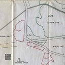
Ingliston, Subsided Land Under Water
code: 195461
Description
Map drawn by the Mining Engineers Office, Hopetoun Works, Winchburgh. Titled Ingliston, Subsided Land Under Water. Scale 1/2" to 1 chain. Dated 31st March 1920. Shows subsided land close to the mineral railway at Hallyards, with subsided arable land in green (6.455 acres) and subsided woodland in red (2.633 acres).