"Special Reports of the Minerals Resouces of Great Britain. Vol.XXIV, Cannel Coals", published by the Geological Survey in 1915" states:
"The only bed of any consequence lies near the summit of the group, and is known as the Lillies or Johnstone Shale Coal of the Paisley district. It was worked from 1870 to 1886, and supplied all the Renfrewshire oil works. Any reserves left cannot be considerable."
"The Lillies or Johnstone Shale Coal of the Paisley district lies among the Hosie limestones near the top of the group. It averages 2 ft. in thickness, made up of a foot of coal resting upon a foot of ' shale,' each of these occasionally increasing to 20 in. It was extensively wrought to the north of Johnstone (Milliken and Clippens) and also at Linwood, Blackstone, and Walkinshaw. The variations of thickness recorded in the workings show: coal, 9 to 20 in.; shale, 11 to 20 in."
"Two areas where the Shale Coal is as yet untouched may be mentioned. The first lies north of Linwood, between Middleton and Blackstone House. Here, from the outcrop down to a depth of about 80 fms., there is about half a square mile in which only one small trial has been made :-a pit having been sunk at a point 500 yds. N.W. of Middleton farm-house, 41 fms. to the shale; but so many'' wants" were encountered that the attempt was abandoned. This adverse feature is probably quite local, and the field may well be worth further exploration. The largest extent of unworked ground lies west of Inchinnan. Here the seam occupies a basin, extending over a square mile from its outcrop down to the deepest part south of Bottom farm-house, where it must lie at a depth of 70 fins. Two bores have been put down in this basin, one of which (in 1869) south of Greenhead, found 1 ft. of coal and blaes resting on 22 in. of oil-shale: at a depth of 35 fms.; the other-at the point where the road to Allans leaves the main highway-got 23 in. of shale at the same depth : in both these bores the overlying coal was in two leaves, separated by a 40-ft. bed of sandstone. The shale is thicker here than at Clippens, as is also the case at Walkinshaw, not far to the south, where the coal and shale measured 16 in."
"The yield of oil from the shale in the Clippens and Milliken workings was 40 gallons or more per ton. As regards sulphate of ammonia, we have no figures, but few of these ''parrot" shales yield more than 20 lbs. per ton."
Five oil works (Blackstone, Blackstoun, Clippens, East Fulton, Inkerman, and Linwood) are known to have operated at various times between 1868 and 1885 in an area of Renfrewshire immediately to the north of Johnstone and north west of Paisley. These works produced a crude oil from Lillie's coal shale, a cannel coal found in seams seldom more than a foot thick, normally association with a seam of common coal and in the proximity of seams of ironstone and other minerals.
The earliest mineral workings in the area were for coal and ironstone, with the shale sometimes being discarded as valueless waste. Some of the early oil companies purchased supplies of shale from the established coal and iron-masters of the area, but most worked mines on their account, often selling on the coal and other minerals worked in association with the shale. Lillie's coal shale was relatively rich in oil, but produced a crude oil that was costly to refine.
As the shale oil industry became established in the Lothians, the Renfrewshire coal-oil industry found it increasingly difficult to compete. The Clippens oil company succeeded in transferring their operations to Midlothian, for a period shipping crude oil across Scotland to be refined at their old works in Renfrewshire. The merger of the Walkinshaw and Hermand oil company sought to achieve similar objectives, but met with less success. Ironstone and coal continued to be mined in the area after oil production had ceased, the last pit closing in 1915. Bricks continued to be manufactured at several of the oil works sites, often using spent shale and waste from mine head tips.
Lillie's Coal Shale is a form of cannel coal that has a laminated appearance and splits easily due to the many microscopic layers of coal that run through it. The coal shale is rarely more than a foot thick and is invariably found immediately below a seam of common coal which also seldom exceeds a foot in thickness. The Lillie's seam is found throughout coal measures from Renfrewshire as far east as Bathgate, but in most places is no more than a few inches in thickness. The shale was only ever worked for oil production in Renfrewshire.
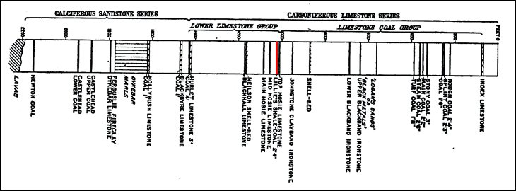
This general section of the Carboniferous strata in the Paisley and Johnstone areas (reproduced from Memoirs of the Geological Survey Scotland.- The Economic Geology of Central Coalfield of Scotland Area IV - published 1920), shows the position of the Lillie's seam at the top of the Lower Limestone Group, about 50 feet below the Johnstone Clayband Ironstone.
The Lillie's shale, and the coal that lay immediate above it, were invariably worked together. Most shafts to the Lillie's shale will have first passed through the Blackband Ironstone seam, and often both minerals were worked from the same pit.
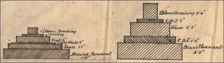
These diagrams, (taken from a plan of the Abercorn and Douglas pits - BGS abandonment plan 1726), illustrate (left) the thinness of the shale and coal seams and suggests that fireclay and blaes had also worked to access the productive seams. A section of ironstone workings (right) similarly illustrates the large quantity of waste blaes that had to be worked to access the thin bands of Clay Band Ironstone.
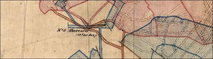
A further detail from BGS abandonment plan 1726, shows a typical arrangement in which shale (coloured red) and clayband ironstone (coloured blue) were worked from a common shaft. Stone mines, (tunnels driven through unproductive strata to reach minerals) are marked in brown. A note on the plan records a distance of 11 to 13 fathoms between the shale and the ironstone workings; ironstone being uppermost.
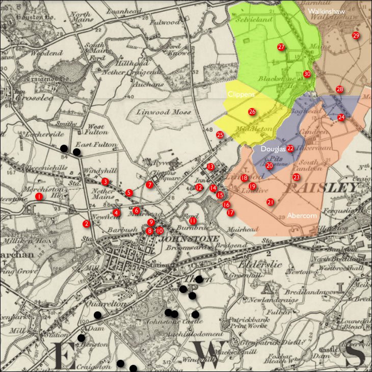
Lillie's shale was worked at various pits beneath the flat carseland lying to the the north of Johnstone and to the south of the River Gryfe. Little documentary evidence survives of the precise location of many pits, or the minerals produced at each. The first edition OS map, surveyed c.1857, illustrates the area at a time when ironstone mining was well established but the oil industry had yet to emerge. By the second survey (c. 1894) all oil production in the area had ceased. With few surviving mine plans, the location of many significant workings remains a matter of conjecture.
The plan below superimposes current Geological Survey data (contains British Geological Survey materials © NERC 2014) over the 1" OS map c.1895. The Kilbarchan Sill; a major intrusion of volcanic rock, (coloured violet), runs SW to NE. To the south of this sill are the rocks of the Lawmuir Formation (coloured gray) which contained seams of coal worked at sites marked in black. To the north of the sill lies the Limestone Coal Formation (coloured buff) which was mined for ironstone, Lillie's coal shale, and other minerals marked in red. Limestone area are marked in light blue.

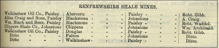
This list of shale, coal, or ironstone workings draws on all available evidence but seems unlikely to be comprehensive. Most surviving documentary sources, such as annual mineral statistics, indexes of mine abandonment plans, or trade directories, normally refer to mining areas rather than individual shafts. Further details of workings are therefore described by area;
Official Statistics record that production of shale in Renfrewshire was 72,660 tons (in 1873) and 97,273 tons in (in 1885) representing 10.1% and 6.6 % of total Scottish shale output respectively.
From Mineral Statistics 1883
Coal mining in the rocks of the Lawmuir Formation to the south of Johnstone dates back to the pre-industrial period. Pigot's directory of the Paisley area (1837) lists coal works at Sandiholes, Craigends and Hallhill near Johnstone, while the first edition OS map (c.1857) shows active coal mines at Auchinlodoment, Wallace and Temperance around Johnstone Castle in the Quarrelton district.
There appears to have been little mining activity to the north of Johnstone, in the rocks of the Limestone Coal Formation, until the 1850's and the beginning of large scale ironstone working. The developing main line railway network enabled ironstone and other minerals to be transported from outlying districts to supply established ironmaking centres in Lanarkshire and Ayrshire. During the early 1850's a number of ironmasters secured mineral leases within the area;
These ironstone workings seem also to have produced household coal for resale, whilst the poorer quality coals (and perhaps coal shale) were consumed in calcination of the iron ore. The calcination process usually took place at the pithead and involved layering ironstone and coal in a heap which was then burned to produce an enriched ore.
Opening up of the ironstone workings required a great influx of labour and the construction of workers' housing. A new village constructed by Merry & Cunningham close to their Abercorn and Douglas pits was named Inkermann after the British victory in the Crimean war, which was ongoing at the time. Housing in the Linwood estate was similar named "Balaclava" and "Redan" after other victories in the Crimea (although marked as "Linwood Square" and Redhand Rows" respectively on OS maps.)
The boom in new oil businesses during the late 1860's brought interest in Lillie's coal shale, which until then had been considered a waste product of little value. Glasgow oil merchants James Greenshields & Son were first to establish an oil works at East Fulton, quickly followed by the Clippens oil works, backed by Robert Binning & Son, another established Glasgow oil business. By 1872, the Linwood works of James Anderson & Sons, the Inkerman works of the Abercorn Oil Company and the Blackstone works of Allan Craig & Sons were also in operation. With the exception of the Clippens Shale Oil Co., all of the oil companies acquired mineral rights and worked their own pits, most selling on the coal and ironstone mined along with the coal-shale. The Clippens company initially contracted with Merry & Cunningham for the supply of coal shale, but purchased the Clippens pits from that company in 1876.
There is evidence of a trade in coal shale between the various oil companies, coal and ironmasters active in the area, sometimes allowing an oil works to draw on alternative sources of supply in the event of strikes and other disruptions. Many of the oil companies were involved in the manufacture of bricks, using the fireclays and blaes worked along with the coal-shale and sometimes spent shale and other waste accumulated in pit bings. In some cases the hot gasses from oil retorts were used to fire the brick kilns.
Increasing competition and declining prices meant that little profit was made from oil production from the late 1870's onwards, however many of the oil companies were sustained for a period by the continued production of coal and other minerals. Ultimately some mineral leases reverted back to the original ironmasters, ironstone working was resumed and new brickworks were constructed, consuming the wastes of past industry. The closure of Walkinshaw No.2 pit in 1915 marked the end of mining in the area, although bricks continued to be manufactured into the mid 20th century.
Ordnance Survey maps reproduced by kind permission of the Trustees of the National Library of Scotland.
1" OS map, with overlay showing estate boundaries (no information on western area)
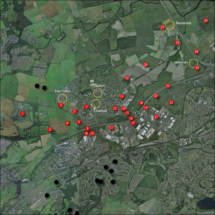
Google earth image, showing location of oil works.
MEETING OF ROAD TRUSTEES. COUNTY OF RENFREW. The first matter brought before the meeting was an application from Messrs Merry & Cunninghame to make a railway crossing on the turnpike road near Linwood into the mineral field of Clippens. …..They had granted a similar application to Messrs Dunlop a few years since, and they could not refuse one to another mineral company, on the same road, and in the same circumstances. ...The level crossing belonging to Messrs Dunlop is one which the lands of the same proprietor is on both sides of the road; while this proposed crossing will run from the lands one proprietor to that of another. …... Soon there would be no necessity for level crossings at all, a branch railway was projected, giving this mineral field a railway connection; and it was not necessary that the public should be forced to submit to the dangers of a level crossing.
The Paisley Herald and Renfrewshire Advertiser, 1St November 1862
EXTENSIVE BUILDING OPERATION.—The village of Balaclava being found inadequate to accommodate the number miners now required in the district from increased shale works, operations have been commenced by Messrs Merry & Cunninghame for the erection of fifty additional houses the eastern side, and to form part the village.
The Paisley Herald and Renfrewshire Advertiser 20th April 1872
DEPRESSION OF THE SHALE OIL TRADE – The prosperity attending the shale oil trade in the neighbourhood of Johnstone his suffered such a relapse, in consequence of the low prices for the oil, that some of the proprietors of the works have judged it expedient to cease manufacturing it, and have extinguished their retorts and discharged the men engaged at them. Messrs James Anderson and Co. suspended their manufacturing operations on Friday, and Messrs Liddell and Co. on Saturday. The Clippens Shale Oil Company continue their refining operations, but they stand in an exceptional portion in as much as they receive their coal and shale under contract that was made a number of years ago.
The Paisley and Renfrewshire Advertiser, 31st January 1874
The Miners of the Johnstone District;— For three or four weeks the miners employed in the Clippens pits, numbering about 900, have been out on strike, and at present there not the slightest sign of the dispute being settled, and, a consequence, about one-half of the oil workers have been thrown out of employment for want of shale, only the refining portion of the extensive works being now in operation; while the adjoining pits belonging Craig, Liddell, and Dunlop are also stopped—in all about 15, some on strike, and others, such as Dunlop's, being suspended on account the Clyde Ironworks stopped.
The Glasgow Herald, 24th September 1879
THE COALFIELDS AROUND PAISLEY
Dr. Robertson, of Renfrew, delivered a lecture the other evening to the members of the Paisley Philosophical Society on the above subject. He said that in a coalfield in Milliken, near Johnstone, a coalmaster, in the course of his investigations, found at a depth of 17 fathoms below a seam of lime and coal — which was at one time regarded by miners and mineralogists as the lowest workable seam, another coal of about 2 feet 9 inches thick, of a peculiar tarry nature, and which had been named the "Lady Ann" coal. This seam was very irregular. Until very recently the opinion remained unchanged as to the practicability of working under the old seams; but, owing to a growing desire to investigate the truth, and owing to the near termination of Young's patent for the distillation of coal oils, the attention of coalmasters and others was directed to three great deposits of shale and blaze lying in a region formerly little explored, and either placed nowhere in the geological section or considered a debatable land. The tract of country to which he referred extended from South Queensferry on the Firth, by Ratho, Uphall, Broxburn, Westfield, and the Calders.
Near Paisley, and between it and Linwood, the lower B.B. ironstone has long been wrought. This seam of lime and coal will probably be found in this tract to underlie the BB from 85 to 100 fathoms at the most. Proceeding north through Linwood occurred a number of ironstone pits, which worked C.B. Now, this C.B. ironstone is known to underlie the B.B.. 45 or 50 fathoms, the strata therefore crop out or come to the surface in the s direction. Under these workings this seam will be found at a depth of 40 or 45 fathoms ; and a little farther north, at Darluth and round the margin of the basin at Sandholes, the upper strata formerly spoken of in entirely off, and this coal seam has been exhausted. From the cast, then, of this extremity or margin of the coal basin away towards Govan including the whole valley of the Clyde bound on the north by the great dyke which almost marks the course of the Roman wall, including Duntocher and Yoker, and Whiteinch, across by Govan, bending west by Cardonald to the north of Paisley and back by Johnstone, is one unbroken expanse of low-lying ground, containing at least thirty-six square miles of this seam of coal and lime, together with the overlying ironstones and oil shale, and this at a depth nowhere exceeding 120 fathoms. Under this tract of country there exists abundance of fossil fuel, and to give general results the lecturer did not think that it could contain less than 1,5,000,000 tons of what he considered a good strong fuel, fit for manufacturing purposes. All these vast stores of mineral treasure simply meant that the various important industries of Paisley and the surrounding district shall have for many years a prosperity not hitherto attainable and a circulation of money hitherto unequalled.
The Manchester Evening News 23rd March 1873
Sources of Mineral Wealth.—We hear that the Laigh-lands, below Paisley, are in the way of being leased for the ironstone and minerals therein. The neighbourhood of Johnstone bids fair to become another Coatbridge or Airdrie. We learn that it is only clay-bands of iron that are wrought in that quarter, but very good in quality; and, as the black-band is now well wrought out, the ironmasters are securing the clay-bands near their works, rather than remove their works, &c., far up into the moors of Ayrshire, Wigton, or Dumfries. It is in these moors seams of coal, eleven or twelve feet thick, and not more than from 20 to 30 fathoms in depth of pit, are at present wrought for country sale. In one of these seams gas-clay of 20 inches, excellent in quality, is found. This is sent to Ayr and ?. The South-Western rails pass within mile and a half of one of these pits.
The Paisley & Renfrewshire Advertiser, 20th October 1855
Minerals of the Lands.- We learn that the lands of Merksworth have been let for some time to Messrs Merry and Cunninghame. We understand that the lessees are not going to bore to prove the lands, but going to sink it at once, being satisfied of what might be obtained. We observe that boring has begun at the Knock Farm, thereby presumed to be let. Mr. Dixon has again resumed boring in the lands of Elderslie, a little past the West Toll. It reported that the Hurlet coal has been proven by boring in the own Moss-lands. If that be at the depth of eighty fathoms, the blackband ironstone ought also to have been found, and likewise the clayband ; but what the thickness thereof, and, of course, its likelihood of being wrought, has not transpired. It is said that within the next five years no fewer than from ten to a dozen pits will be in active working order, where from 1,500 to 2,000 miners, and about 500 labourers, will find employment.
The Paisley & Renfrewshire Advertiser, 4th October 1856
Diabolical Act.—On Friday night, some one or other thrust a piece of metal between the teeth of the spur wheels connected with the gearing of No. 1 Ironstone Pit, near Johnstone, the property of Messrs Colin Dunlop & Co. Fortunately it was noticed before the engines had been set going, or the consequences might have been disastrous, as a party of miners were just preparing to descend. A reward of £10 has been offered for the apprehension of those guilty of this diabolical conduct.
The Paisley & Renfrewshire Advertiser, 12th February 1859
Serious Pit Accident.—A serious accident occurred Tuesday morning No. 1 Ironstone Pit, on Portnauld Farm, Inchinnan It appears that the miners had reached the working to begin their labour, and that the oversman, Alex. Kennedy, was engaged examining the place with a safety lamp in case of the existence of fire-damp. had reached a part of the working, accompanied by other three miners, and was in the act of waving his coat, the usual mode of dispersing any fire-damp which may have collected, when sudden explosion took place. Two of the men who were beside him were fearfully burned, namely. John Easton, who has suffered most, and Andrew Downie, both young unmarried men, residing in Renfrew. Another named Patrick Hannigan, a married man, residing in Barrhead, and Kennedy, were also slightly injured. The two first named were taken home, where they lie in a precarious condition. The pit in which the accident occurred is one of several which have just been opened, or are in course of being opened, by the Langloan Iron Company, on the estate of Mr. Campbell, of Blythswood.
The Paisley & Renfrewshire Advertiser, 28th July 1866
PURCHASE or COAL WORKS AT BLAIRDARDIE.— we learn that Messrs. Merry & Cunninghame of Ironstone Works, have purchased from Mr. Robertson, Renfrew, the coal works here, including plant, houses, &c. An excellent seam of ironstone has been discovered, and it expected that the new proprietors will make for commencement shortly.
The Paisley & Renfrewshire Advertiser, 9th September 1871
Enquiry form